


Perihal Map Pad GPS Land Surveys & Measurements
Use MapPad to calculate areas, perimeters and distances and save, export or share your measurements.
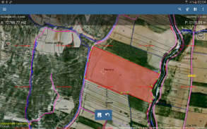
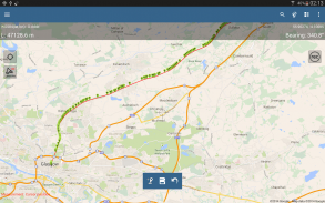
MapPad is providing multi-purpose mapping solution allowing location capture and determines distance and area for the shapes drawn on the map or captured using real-time GPS tracking.
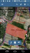
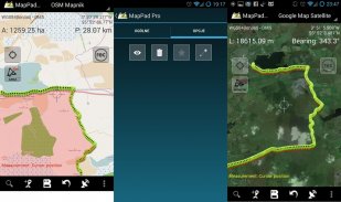
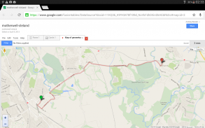
Calculate area of the field or a walk distance instantly using Google or Bing Map Satellite view. Save petrol and time and capture features with few clicks on the map.
With MapPad you can capture, manage and share your data easily.
MapPad is a very useful tool for anyone involved in forestry, agriculture, engineering and real estate management.
Please visit our website to find out how to prepare offline map and get more information about this product.
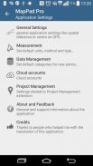
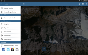
Selected features:
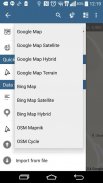
- Base maps: Google Maps, Open Street Map, Bing Maps
- Google Maps Overlays (Custom WMS or ArcGIS Server Tiled service), some layers like US Topographic map have been predefined.
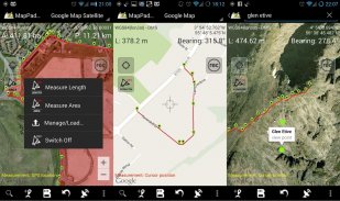
- Very accurate measurement of areas and distances.
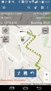
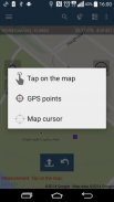
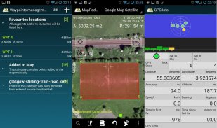
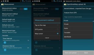
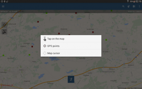
- 3 methods of measurement are supported (Tap on the map, GPS location, Map cursor location).
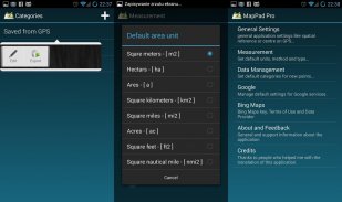
- Support for number of metric and imperial units.
- Support for several global and local coordinate systems, if you require support for any other spatial reference please get in touch.
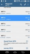
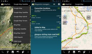
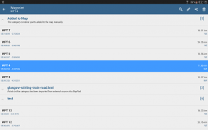
- Possibility to capture waypoints and group them in categories.
- Possibility to add or edit title and description for each recorded measurement and waypoint.
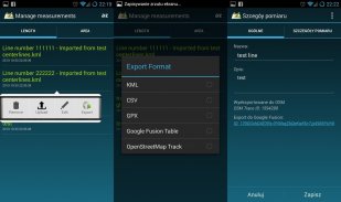
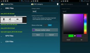
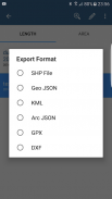
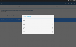
- Export single or multiple measurements or waypoints to SHP File, Geojson, ArcGIS Json, KML, GPX, CSV and DXF to SD Card or cloud services las well as direct export to Open Street Map.
- Share single waypoint location directly by SMS, E-mail or other ways.
- Elevation profile available for measurements done by GPS.
- Import of KML and GPX files to the application.
- GPS status and satellites status.
- Address, location search.
- Quick open exported KML files in Google Earth
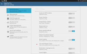
- Ability to set default measurement units, waypoints' categories colours, track recording time and distance interval, transparency of Google Maps overlays and much more...
Our users are successfully using MapPad in number of projects and applications.
Gunakan MapPad untuk mengira kawasan, perimeter dan jarak dan menyimpan, mengeksport atau berkongsi pengukuran anda.
MapPad menyediakan penyelesaian pemetaan pelbagai guna yang membolehkan lokasi menangkap dan menentukan jarak dan kawasan untuk bentuk yang ditarik pada peta atau ditangkap menggunakan penjejakan GPS masa nyata.
Kirakan kawasan medan atau jarak berjalan dengan serta-merta menggunakan paparan Satelit Peta Google atau Bing. Simpan petrol dan masa dan ciri tangkapan dengan beberapa klik pada peta.
Dengan MapPad anda boleh menangkap, mengurus dan berkongsi data anda dengan mudah.
MapPad adalah alat yang sangat berguna untuk sesiapa yang terlibat dalam pengurusan perhutanan, pertanian, kejuruteraan dan hartanah.
Sila layari laman web kami untuk mengetahui cara menyediakan peta luar talian dan mendapatkan maklumat lanjut mengenai produk ini.
Ciri terpilih:
- Peta asas: Peta Google, Peta Terbuka Jalan, Peta Bing
- Lapisan Peta Google (Custom WMS atau perkhidmatan ArcGIS Server Tiled), beberapa lapisan seperti peta Topografi AS telah dipratentukan.
- Pengukuran kawasan dan jarak yang sangat tepat.
- 3 kaedah pengukuran disokong (Ketik pada peta, lokasi GPS, Peta kursor peta).
- Sokongan untuk bilangan unit metrik dan imperial.
- Sokongan untuk beberapa sistem koordinat global dan tempatan, jika anda memerlukan sokongan untuk rujukan ruang lain sila hubungi.
- Kemungkinan untuk menangkap titik jalan dan sekelompoknya dalam kategori.
- Kemungkinan untuk menambah atau mengedit tajuk dan perihalan untuk setiap ukuran dan titik laluan dirakam.
- Eksport pengukuran tunggal atau berbilang atau titik jalan ke SHP File, Geojson, ArcGIS Json, KML, GPX, CSV dan DXF ke SD Card atau perkhidmatan cloud las dan eksport langsung ke Open Street Map.
- Kongsi lokasi jalan tunggal secara langsung melalui SMS, E-mel atau cara lain.
- Profil ketinggian tersedia untuk pengukuran yang dilakukan oleh GPS.
- Import fail KML dan GPX ke aplikasi.
- status status GPS dan satelit.
- Alamat, carian lokasi.
- Fail KML yang dieksport terbuka di Google Earth
- Keupayaan untuk menetapkan unit pengukuran lalai, kategori warna titik, masa rakaman trek dan selang jarak, ketelusan lapisan Google Maps dan banyak lagi ...
Pengguna kami berjaya menggunakan MapPad dalam bilangan projek dan aplikasi.
Map Pad GPS Land Surveys & Measurements - Versi 7.5.0
(19-05-2019)
Map Pad GPS Land Surveys & Measurements - Maklumat APK
Versi APK: 7.5.0Pakej: com.osedok.mappadAplikasi dalam kategori sama
Anda juga mungkin suka...


